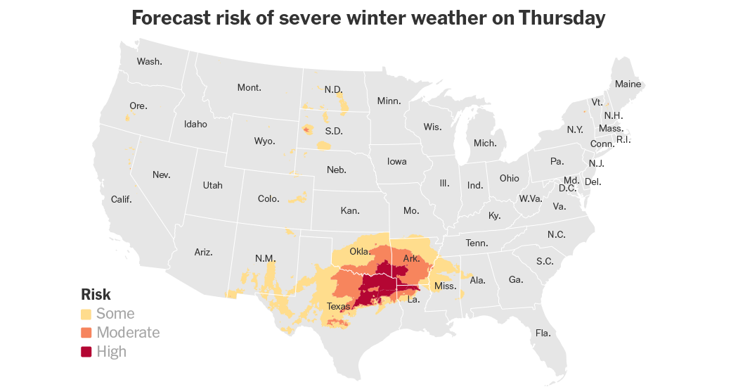
A strip of what forecasters are calling “heavy snow and disruptive ice” is expected to pile up across the South through the end of the week. From the southern plains of Texas and Oklahoma to the Carolina coastal plains, much of this winter precipitation is forecast to fall on places where people are less accustomed to winter weather, and it is likely to cause hazardous driving conditions, power outages and school closures.
Key things to know
-
In the Southern United States, it doesn’t take huge amounts of snow or ice to disrupt everyday life.
-
Over a half foot of heavy snow is expected to create dangerous travel conditions along and south of Interstate 40 across Oklahoma, Arkansas and Tennessee.
-
Farther south, along and just north of Interstate 20 from Texas to Georgia, snow is likely to change to sleet and freezing rain as warmer air noses in above the freezing temperatures at the surface.
-
The region will continue to see cooler temperatures into next week, prolonging the likelihood of hazardous travel conditions.
Early Thursday morning, the snow was already falling across northern Texas and into Oklahoma as the storm began to take shape in the Gulf of Mexico before an expected shift to the northeast. The heavier snow is likely to remain in northern Texas and into Oklahoma. The most likely snowfall totals in Texas will be between two and four inches, mainly along and north of I-20, in an area that averages less than two inches per season.
Anticipating the potential effects, Dallas schools will be closed on Thursday and Friday. Gov. Greg Abbott used a news conference on Wednesday to warn drivers: “Be careful. Be cautious.”
“We’re not used to driving on ice and snow,” he said to his fellow Texans. “We’re not used to driving in conditions like this.”
More than 1,000 flights scheduled for Thursday were canceled at Dallas Fort Worth International Airport, according to FlightAware, a flight tracking website. More than 200 flights were canceled at Dallas Love Field Airport.
As the storm crosses the Gulf of Mexico on Thursday into Friday, any slight change in its path could result in precipitation that differs from the forecast in a given area. A slightly more northern track would shift the heavier snow farther north and lift the line of freezing rain and sleet. A more southern track would do the opposite, bringing the heavier snow deeper into the South and leaving the northern areas dry.
Winter precipitation is expected across Texas, Oklahoma and Arkansas from Thursday night into Friday. By early Friday morning, it will have surged farther east across Tennessee, northern Mississippi, Alabama and Georgia. While Tennessee is no stranger to winter storms, some areas, like Memphis, could receive their largest two-day snow total in 40 years.
Forecasters in Nashville reminded locals not to become hung up on the precise amounts, as any snow could cause hazardous travel in the region. In Atlanta, it has been nearly 11 years since a small snowstorm, locally referred to as snowmageddon, shut down the city and became a punchline for a “Saturday Night Live” skit.
While snow has fallen in the city since then, it may still catch people off guard as the type of precipitation changes through the day. What is expected to start as snow Friday morning is likely to turn to sleet and then freezing rain across the Atlanta metropolitan area, turning untreated roads into ice skating rinks by the evening hours.
Gov. Brian P. Kemp of Georgia declared a state of emergency on Thursday because of the forecast and said it would be in place through Tuesday. The governor asked residents to avoid travel as much as possible in the next few days. “Hazardous conditions, including ice and snow, can develop quickly and make travel very dangerous,” he said in a statement.
Across North Carolina, a similar scenario will begin to unfold around midday Friday and last overnight into Saturday. Accumulations of up to two inches are currently expected in the Mid-Atlantic area east of the Allegheny Mountains.
The storm is then expected to move off the coast, where it will strengthen but remain far enough away to avoid being a major hazard for the Northeast.
Abnormal cold across the East Coast is expected to continue into next week, allowing for some snow to stick around. And where the snow has melted during the day, it may refreeze at night, creating ongoing transportation hazards.
Amanda Holpuch contributed reporting.


