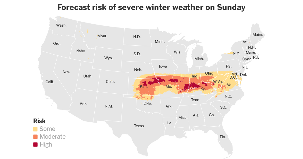
About a dozen of states across the middle of the country were braced on Saturday for a strong winter storm accompanied by Arctic cold that is poised to bring “significant wintry weather” from the Central Plains to the Mid-Atlantic, according to the Weather Prediction Center.
Some places may get their heaviest snowfall in a decade or more, forecasters said early Saturday as widespread winter storm warnings took effect.
The storm is expected to bring a nasty mix of sleet, snow and freezing rain that is likely to disrupt travel and daily life with road closures, flight delays and power outages beginning Saturday and lasting through Monday.
As the storm moves on, Arctic air is predicted to settle in its wake, as some of the most frigid temperatures of the season are expected to linger for days.
Some state officials were already gearing up for the worst on Friday.
In Missouri, the governor put the National Guard on standby, and Gov. Glenn Youngkin of Virginia declared a state of emergency, days ahead of the storm’s arrival, and urged people to avoid traveling on Sunday.
Cities from Cincinnati to Chicago to St. Louis began the work of pretreating their roads and preparing warming centers.
The low-pressure system will push into Denver on Saturday evening with up to an inch or two of snow projected to fall in the metro area overnight. The storm is forecast to strengthen quickly as it exits Colorado and moves into the Central Plains by late Saturday.
“We’re on the weaker side of it, and then it quickly wraps into a much more potent storm as it gets into Kansas and Nebraska,” said Zach Hiris, a meteorologist with the National Weather Service office in Denver.
Heavy snowfall whipped up by wind gusts over 35 miles an hour could bring blizzard conditions to the Central Plains by Sunday morning.
Whiteout conditions could make driving “dangerous to impossible” in some areas, the Weather Service warned.
The storm will continue its march eastward, reaching the Ohio and Tennessee Valleys on Sunday, and the Mid-Atlantic region Sunday night into Monday.
There was an enhanced risk, the second level out of five, that severe thunderstorms on Sunday could form in parts of the Lower Mississippi Valley and bring lightning, wind gusts, hail and tornadoes.
At least eight inches of snow is predicted for a region stretching between central Kansas and Indiana from Saturday into Sunday, with additional snow showers potentially lingering into Monday.
The Weather Prediction Center said some of the most extreme conditions are likely in places to the north of and running along the Interstate 70 corridor, which passes through St. Louis and Indianapolis.
Moderate lake-effect snow could also hit the Upper Great Lakes and Lake Erie through Sunday morning, forecasters said.
The geographic scope of the storm was still taking shape on Friday afternoon.
Rich Bann, a meteorologist with the Weather Prediction Center, said that while snow was likely to stay south of the Great Lakes, “it may not take that much of a shift, and then maybe Chicago gets more than we’re expecting right now.”
The Prediction Center also warned of “significant icing potential” in the mid-South this weekend. Sleet and freezing rain could wreak havoc from eastern Kansas and the Ozarks, stretching east to the Tennessee and lower Ohio Valleys.
“That rain will freeze on contact and turn to glazing — that’s what sticks to the trees, power lines, roads, cars, car windows, everything,” Mr. Bann said.
The southern Appalachian Mountains are also at risk of icing on Sunday and Sunday night.
From Sunday into Monday, the storm is on track to cross the Appalachians and push into the Washington, D.C., area, along with western Maryland, Northern Virginia, Pennsylvania and Delaware.
“We’re looking at precipitation beginning in earnest on Sunday, continuing Sunday night into Monday before it all wraps up,” Mr. Bann said.
The storm is arriving at a time when the country is poised to experience what the National Weather Service is calling a “significant Arctic outbreak.”
Temperatures are expected to plummet to below average in areas east of the Rocky Mountains, reaching as far south as the Gulf Coast and Florida, with the frigid weather lasting into mid-January.
Isabella Kwai contributed reporting.


