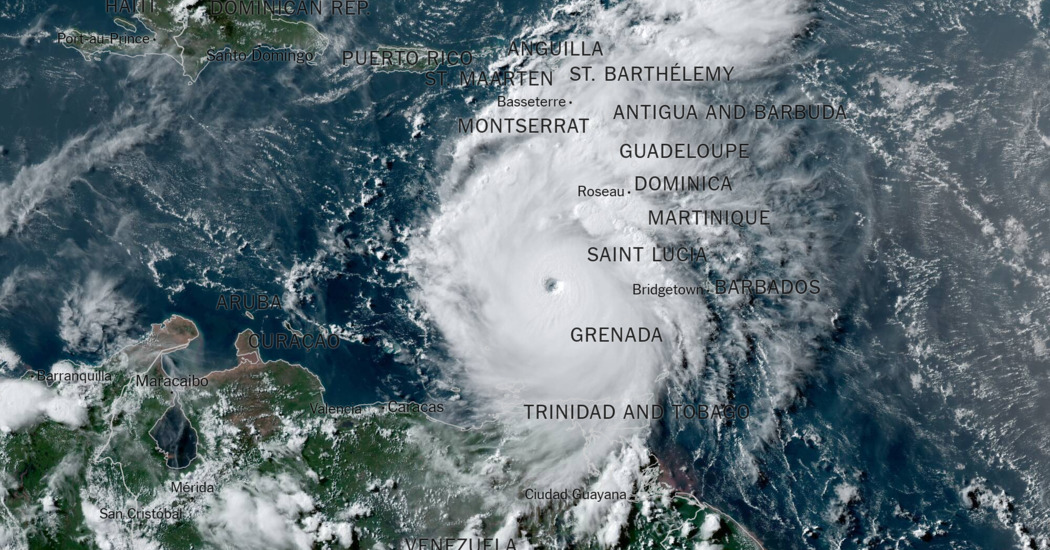
Hurricane Beryl rapidly intensified from a tropical storm to a Category 4 hurricane in two days as it rushed toward the Caribbean this weekend, increasing its wind speed by 45 miles per hour daily. (It later grew to Category 5 strength.)
This quick escalation was a direct result of the above-average sea surface temperatures as well as a harbinger of what is to come this hurricane season.
“This early-season storm activity is breaking records that were set in 1933 and 2005, two of the busiest Atlantic hurricane seasons on record,” said Philip Klotzbach, an expert in seasonal hurricane forecasts at Colorado State University.
Last fall, a study in the journal Scientific Reports found that Atlantic hurricanes from 2001 to 2020 were twice as likely to grow from a weak storm into a hurricane of Category 3 or higher within 24 hours than they were from 1971 to 1990. The study added to a growing body of evidence that rapidly developing major hurricanes were becoming more likely.
Andra Garner, an assistant professor of environmental science at Rowan University in New Jersey and the author of the paper, called the findings an “urgent warning.”
A hurricane that intensifies faster can be more dangerous, as it allows less time for people in areas projected to be affected to prepare and evacuate. Late last October, Hurricane Otis moved up by multiple categories in just one day before slamming into Acapulco, Mexico, as a Category 5 hurricane that killed at least 52 people.
It is no surprise to meteorologists that Beryl was able to strengthen so quickly and behave more like a peak-season storm. Hurricanes suck up warm ocean water and use it as fuel. In an optimal weather environment like this past weekend’s, the ample heat energy rapidly increases the storm’s intensity.
Abundantly warm ocean temperatures in the Atlantic Ocean have been a concern since last season’s overly active year. On Friday, Beryl formed around ocean temperatures that were warmer than they were this time last year, and are more akin to what they typically would be during the peak of hurricane season, in September. Normally, early-season activity is limited in this portion of the Atlantic because those ocean temperatures are relatively cool.
But now they are hot. That helped Beryl strengthen into the earliest Category 4 hurricane in the Atlantic, and the first to have such strength in June, according to Dr. Klotzbach. Previously, Hurricane Dennis held the record for the earliest Category 4 hurricane, forming on July 8, 2005.
Because of the ocean’s heat, Beryl formed farther east in the Atlantic than any storm has in the month of June, breaking a record set by an unnamed storm formed east of the Caribbean on June 24, 1933.
The warm ocean temperature is one of the main reasons experts have been predicting an extremely active hurricane season this year. It is also why forecasters from the National Oceanic and Atmospheric Administration, who predict there will be 8 to 13 hurricanes this season, believe about half of those will reach major hurricane status, as Beryl did this weekend.
Usually, early-season activity doesn’t have much bearing on the rest of the season’s activity. But, in June, when that activity occurs as far east as Beryl did, Dr. Klotzbach says, “it tends to be a harbinger of a very busy season.”


