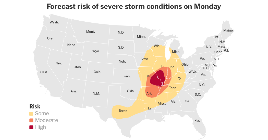
A powerful spring storm is sparking several rounds of severe weather across the Midwest on Monday afternoon. Forecasters with the National Weather Service have focused on parts of Missouri and Illinois where they said several tornadoes — some of which could be quite strong — are the most likely.
“If tornadoes can form, they could be on the stronger side for sure,” said Christine Wielgos, a meteorologist for the Weather Service office in Paducah, Ky.,.
Key things to know:
-
The storms are expected in multiple waves. The first was from Monday morning into the early afternoon, and caused damaging hail as it moved across Missouri. The second wave was expected to kick off later Monday afternoon and last well into the evening.
-
A tornado watch was in place across the southern parts of Illinois and Missouri until late evening. By early afternoon, several brief tornado warnings had already been issued in both states, including for St. Louis and its suburbs.
-
The broader risk for thunderstorms that could produce a tornado includes areas from Chicago back toward Little Rock, Ark. this evening.
Because some tornadoes could be strong, Brian Hays, meteorologist at the Weather Service office in St. Louis, warned people under tornado warnings to “make sure you have a plan to go to the interior room or basement of your home.”
The later round of storms could be potentially more damaging, with hail and at least some potential for tornadoes from Texas to Wisconsin.
Severe weather has rumbled through the central part of the United States for days, but Rich Thompson, the chief of forecast operations at the Storm Prediction Center, said Monday is expected to be the most intense day.
He said the greatest number of storms, and the highest concentration of severe weather, is expected to occur across more densely populated areas, increasing the potential for damage and disruption.
Evan Bently, a meteorologist with the Storm Prediction Center, said there is a chance that the conditions in Missouri and Illinois become a “goldilocks” moment for the worst time of storms to form, when
the ingredients are perfectly balanced for intense storms and tornadoes.
The probability for these types is highest in an area that stretches from St. Louis to Memphis.
In St. Louis, the worst is likely from late afternoon to around sunset. Farther to the south, the worst could last even later into the night.
In addition to the risk of tornadoes, a broader area stretching from the Mississippi Valley into the lower Ohio Valley faces a lower, but notable, threat of severe weather. People in this region, which includes Chicago, Nashville and Milwaukee, could face damaging wind gusts of up to 70 miles per hour and hail up to three inches in diameter.
Some areas may also face flash flooding. Northern and central Missouri, along with much of Illinois and Indiana, are at particular risk. Forecasters at the Weather Prediction Center said the repeated rounds of storms on Monday could produce rainfall rates of up to two inches per hour, especially early Monday over northern Missouri, which may lead to flash flooding.
The severe weather outbreak is part of a broader stretch of active and dangerous weather that has unfolded over recent days. Since Thursday, parts of the Plains and the South have recorded more than 50 tornado reports. Among them was a preliminary EF4 tornado — level four on a five point scale — in Enid, Okla. North Texas was also hit by severe storms producing hail the size of tennis balls and winds gusts up to 89 miles per hour, killing at least two people and displacing dozens of others.
The severe weather threat is expected to ease slightly on Tuesday. Mr. Thompson said it will be a “step down” in intensity, with the tornado risk shifting south, toward North Texas and parts of southern and eastern Oklahoma.
“So just a typical severe weather threat for late April,” he said. “And then the severe weather threat should slowly decrease after that.”