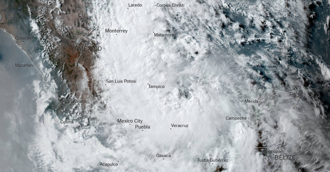
A rainstorm off the coast of Mexico became Tropical Storm Alberto on Wednesday, the first named storm of the Atlantic hurricane season.
While the storm had maximum sustained winds of 40 miles per hour, the main concern was rainfall of a foot or more predicted for parts of Texas and Mexico.
Tropical storm warnings were issued for coastal areas of Texas and northeastern Mexico.
The storm was in the Gulf of Mexico on Wednesday and was headed west toward northeastern Mexico, according to the National Hurricane Center. Forecasters predicted Alberto could make landfall early Thursday near the Mexican city of Tampico, but its effects were expected to extend far beyond that.
In addition to the rain, east-to-northeast winds are expected to gradually strengthen over the next couple of days. Although wind is not the most significant concern with this system, the wind field is expansive and widespread tropical-storm-force winds are expected to extend north from the center of the storm.
With persistent onshore winds, there is a threat of moderate coastal flooding and a storm surge of one to four feet. Another threat is rip currents, which are expected along Gulf Coast beaches in the coming days.
Preparations were underway in Mexico
On Wednesday, the authorities and residents alike were preparing for the heavy rains and strong winds.
Officials were monitoring the levels of dams, rivers and streams, and were also cleaning drainage points, to prevent potential flooding. Government workers were setting up temporary shelters and more than 1,500 electricians were deployed to Tamaulipas, Veracruz and Nuevo León — the three states expected to bear the brunt of Alberto’s force when it makes landfall — to respond to any power outages.
Still, for some states in Mexico, the storm’s arrival was a welcome respite amid a water crisis and scorching heat waves.
“We are waiting for these rains, which are going to be very beneficial,” Luis Gerardo González, the Tamaulipas state civil protection coordinator, said in a radio interview on Wednesday.
Rainfall that the storm brought to southern Mexico also helped temper brutal heat that caused the deaths of 220 primates. The country’s environment agency said on Tuesday that the rains had caused the populations of howler monkeys, which started falling from trees amid the heat last month, to become more active.
Why this season is expected to be busy
Forecasters have warned that the 2024 Atlantic hurricane season could be much more active than usual.
In late May, the National Oceanic and Atmospheric Administration predicted 17 to 25 named storms this year, an “above-normal” amount and a prediction in line with more than a dozen forecasts earlier in the year from experts at universities, private companies and government agencies. A typical hurricane season produces 14 named storms.
The seasonal hurricane outlooks were notably aggressive because forecasters looking at the start of the season saw a combination of circumstances that didn’t exist in records dating back to the mid-1800s: record warm water temperatures in the Atlantic Ocean, and the potential formation of the weather pattern known as La Niña.
La Niña occurs in the Pacific because of changing ocean temperatures and affects weather patterns globally. When it is strong, it typically provides a calm environment in the Atlantic; this allows storms to more easily develop and strengthen without interference from wind patterns that might otherwise keep them from organizing.
John Keefe contributed reporting.